Photo via The Hindu

What’s the issue with the way Africa is shown on maps? | Explained

Read the original at The Hindu ↗
Cite

Mukunth, V. (2026, September 6). What’s the issue with the way Africa is shown on maps? | Explained. The Hindu. https://www.thehindu.com/sci-tech/science/whats-the-issue-with-the-way-africa-is-shown-on-maps-explained/article69963529.ece

Dated when The Aporia collected the article, usually within hours of publication. Check the original for its exact date and byline.

The Hindu · collected 2026-09-06 · by Vasudevan Mukunth

Quick Summary

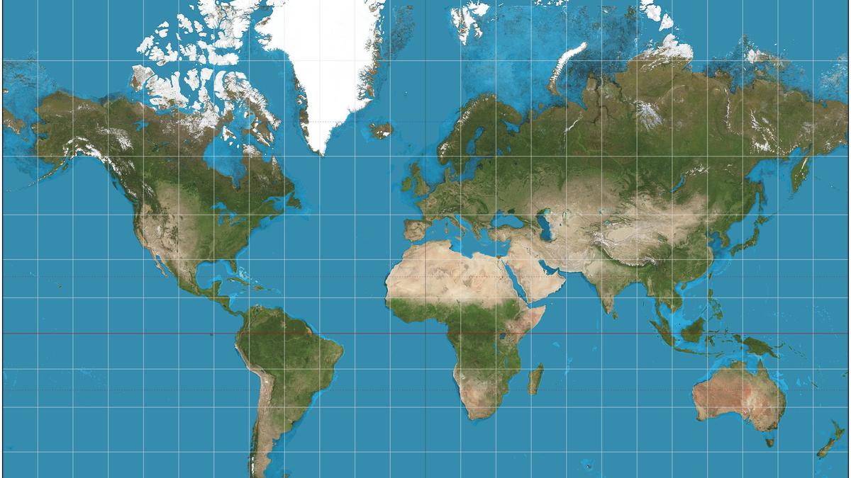
The African Union has endorsed the "Correct the Map" campaign to replace the Mercator map projection with alternative projections that accurately represent landmass sizes. The AU claims that the Mercator projection distorts Africa's size compared to other continents, inflating Europe and North America instead. The Mercator projection was designed in 1569 by Gerardus Mercator to solve navigation problems for sailors, but it systematically alters geographical proportions.
Written by AI on 2026-09-06, from this article's own text only (the story summary below draws on all the coverage).
See how they differ ↓

AI analysis

Story summary

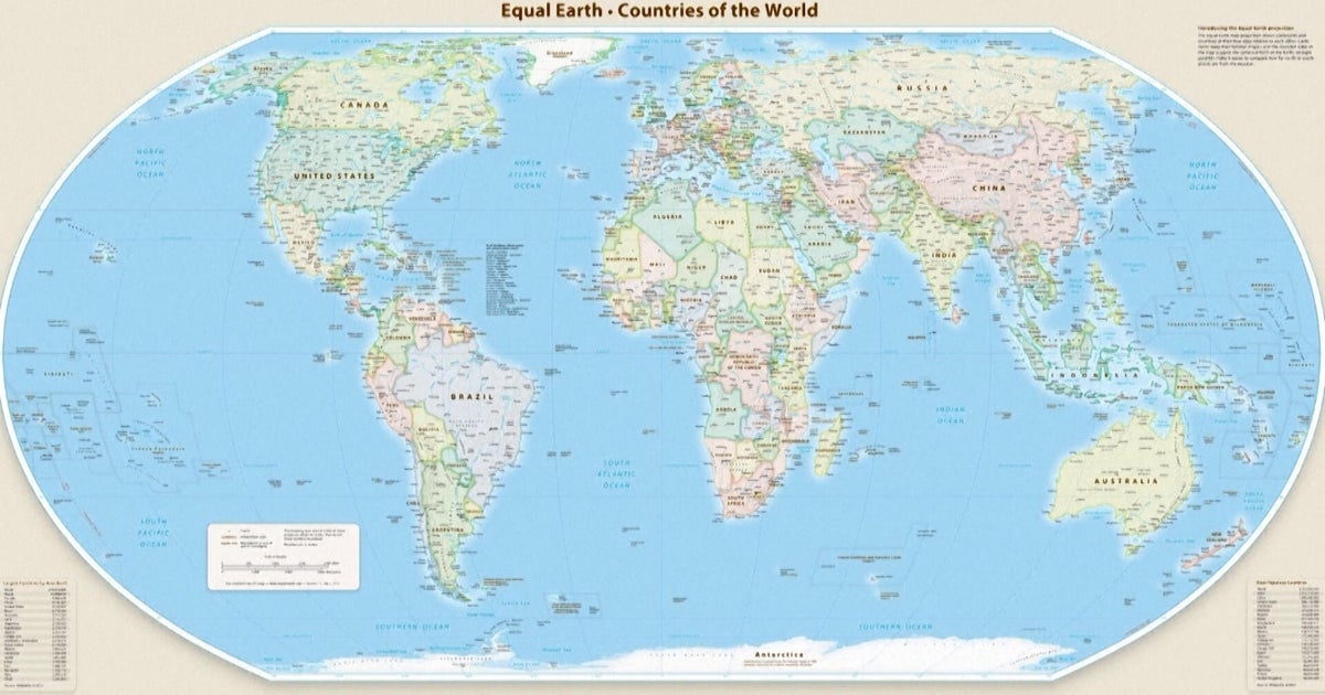
September 4th, 164 countries, including France and the UK, voted in favor of a resolution at the UN General Assembly to adopt a new world map that more accurately reflects the size of Africa. Only the US voted against it, with six other states abstaining. The new map, known as the Equal Earth cartographic projection, aims to provide a more accurate representation of continental landmasses and reduce distortions caused by the traditional Mercator projection, which has been widely used since the 16th century. According to Foreign Minister Robert Dussey of Togo, "a fair world begins with a fair map," highlighting the importance of cartography in shaping our understanding of the world. The resolution promotes the use of the Equal Earth projection over the Mercator projection, which distorts the relative size of land masses by expanding those nearer the poles, making Greenland appear roughly the same size as Africa, although Africa is about 14 times larger.

Written for “UN Adopts New World Map” on 2026-11-20, grounded in this article and the 24 other(s) covering the same event.

How they differ

15 outlets covered “UN Adopts New World Map”.

What each outlet says

One AI summary per outlet of its latest article on this story, written from that article alone and checked against it. Open the article for the outlet's own words.

The HinduThis outlet6 Sep

The African Union has endorsed the "Correct the Map" campaign to replace the Mercator map projection with alternative projections that accurately represent landmass sizes. The AU claims that the Mercator projection distorts Africa's size compared to other continents, inflating Europe and North America instead. The Mercator projection was designed in 1569 by Gerardus Mercator to solve navigation problems for sailors…

What’s the issue with the way Africa is shown on maps? | Explained (this article)4 articles from The Hindu on this story
The Straits Times4 Sep

The United Nations General Assembly voted to adopt a new world map, known as the Equal Earth cartographic projection, which makes Africa larger while shrinking North America and Europe, with 164 countries in favor and the US voting against it. The resolution aims for a more accurate representation of world geography. Six other states abstained from the vote. The new map is intended to replace the traditional…

While You Were Sleeping: 5 stories you might have missed, Sept 5, 2026 →3 articles from The Straits Times on this story
Al Jazeera11 Sep

The United Nations General Assembly voted last week to encourage the use of new world maps that more accurately depict continents with their true sizes, with 164 countries in favor and six abstaining. The US was the only country to oppose the resolution, which promotes the Equal Earth projection over the widely used Mercator projection. India, Ukraine, and Japan have expressed concerns about how disputed territories…

Japan, India, Ukraine: Why some countries are uneasy about new UN map →3 articles from Al Jazeera on this story
The Guardian11 Sep

Japan has asked the operator of a new UN world map, known as the Equal Earth cartographic projection, to revise the map because it incorrectly shows the Kuril islands belonging to Russia. The disputed islands are also known in Japan as the Northern Territories and have been at the center of a long-standing territorial dispute between Japan and Russia. 164 UN members voted to adopt the new map on Friday, but it has…

Japan seeks change to new UN world map over Russia 'misconception' →2 articles from The Guardian on this story
BBC5 Sep

The United Nations has adopted a new map called the Equal Earth projection to replace the widely used Mercator map, which distorts the size of continents such as Africa. The Mercator map was created in 1569 by Flemish cartographer Gerardus Mercator for navigation purposes and still influences many modern maps, including Google Maps. The key issue with the Mercator map is that it makes countries near the equator…

What different world maps get right - and what they get wrong →2 articles from BBC on this story
CBS News6 Sep

The United Nations General Assembly on Friday endorsed a new world map called the Equal Earth projection, which accurately represents Africa's larger size compared to Greenland. The resolution, sponsored by Togo and backed by African countries, was passed with 164 votes in favor, including opposition from only the US, and six abstentions. The new map shows continents in their true proportions, with Africa being 14…

UN endorses new map that shows Africa's size more accurately →2 articles from CBS News on this story
Show 9 more outlets
South China Morning Post4 Sep

The UN General Assembly voted 164-1 on Friday, with six abstentions, to adopt a new map called the Equal Earth cartographic projection. The resolution, spearheaded by African countries, makes Africa appear larger while shrinking North America and Europe compared to the traditional Mercator map. This shift is aimed at achieving "a more accurate representation" of continental landmasses, according to the resolution…

UN adopts new map: Africa bigger, North America and Europe smaller →
Dawn4 Sep

The UN General Assembly voted 164-0 (with 6 abstentions) to adopt a new map that makes Africa appear larger and shrinks North America and Europe. The resolution, led by several African countries, aims for a "more accurate representation" of world geography using the Equal Earth cartographic projection. According to cartographers, this new map preserves the relative surface areas of continents and shows their shapes…

UN adopts major map reform to show true scale of continents →
ABC News (AU)4 Sep

The United Nations General Assembly has voted to adopt a new world map, known as the Equal Earth cartographic projection, which makes Africa appear larger and North America smaller compared to the traditional Mercator projection. The motion was carried by 164 countries, with six abstaining and the US voting against it. The resolution aims to provide a more accurate representation of continental landmasses, with the…

Africa bigger, US smaller as UN votes to adopt a new world map →
NPR4 Sep

The United Nations General Assembly has overwhelmingly backed a resolution, known as "Correct the Map", to change how Africa is represented on world maps. The vote was 164 to one, with six countries abstaining, and the only country voting against it was the United States. The resolution encourages the use of equal-area projections, such as Equal Earth, which more accurately show the true relative size of countries…

The U.N. backs a new world map showing Africa in its true relative size →
National Post5 Sep

The UN General Assembly voted 164-0 (with six abstentions) on Friday to adopt a new world map called the Equal Earth cartographic projection, which makes Africa larger and North America and Europe smaller. The resolution aims to provide a more accurate representation of continental landmasses, replacing the traditional Mercator projection that was designed in 1569 for maritime navigation. France co-sponsored the…

UN adopts ‘more accurate’ world map with larger Africa and smaller North America, Europe →
Times of India5 Sep

The United Nations General Assembly has endorsed a new world map called the Equal Earth projection, which accurately reflects Africa's size. 164 countries voted in favor of the resolution, while the US was opposed and six countries abstained. The new map shows Africa as about 14 times larger than Greenland, whereas under the traditional Mercator projection, they appear roughly comparable in size. The resolution…

A bigger Africa & a smaller Europe: What changes in new UN-backed world map →
Sydney Morning Herald5 Sep

The United Nations has voted to adopt a new world map that more accurately reflects countries' true size, shifting away from the 16th-century Mercator map. The resolution, sponsored by African states, passed with 164 votes in favor and 1 against, with some critics arguing that the Mercator map creates a subtle bias towards northern nations. Africa is about 14 times larger than Greenland, which appears roughly the…

Australia and Africa expand, North America and Europe shrink: UN adopts new world map →
Daily Mail6 Sep

The United Nations General Assembly has voted to adopt a new world map, known as the Equal Earth projection, which makes Africa appear larger and corrects what critics call "cartographic colonialism". The resolution, sponsored by Togo and backed by 164 member states, aims to move away from the centuries-old Mercator map. A key aspect of the change is that Africa will appear about 14 times larger than it does on the…

United Nations adopt new world map that shows Africa much bigger and cuts size of UK and US →
The Independent6 Sep

The UN General Assembly has voted in favor of a resolution sponsored by Togo to replace traditional world maps with more accurate representations of nations' sizes. The "Correct the Map" resolution passed with 164 votes in support and was opposed by only the US, with six other countries abstaining. The resolution encourages governments, schools, and companies to use maps that accurately depict Africa's size, which…

UN votes to approve new world map which will show true size of Africa →

Where they agree and split

Agreed

Reported by outlets on both sides of the middle

“Maps shape our understanding of the world,” Togo’s foreign minister Robert Dussey was quoted by the UN as saying ahead of the vote.

9 outlets
Show 3 more

The "Correct the Map" resolution, sponsored by Togo and backed by African Union (AU) members, passed with the support of 164 nations, including France and the UK.

6 outlets

France – which co-sponsored the resolution in support of the new map – announced on Sept 4 that it would abandon the Mercator projection.

5 outlets

“They are therefore never neutral, when they present a distorted image of our planet, they risk perpetuating inaccurate representation that are passed down through generation.”

4 outlets

Disputed

Picked by our model, which is sometimes wrong

  • The US representative criticized the resolution as a reason for the UN losing credibility, whereas other countries supported it.45

Framing

How the first headlines put it

  • South China Morning Post and The Straits Times emphasize that Africa is shown larger while North America and Europe are smaller in the new map.13
Stated as fact12
The headlines (12)

UN votes to adopt new world map that shows Africa’s true scale The Guardian · stated as fact

UN adopts new map: Africa bigger, North America and Europe smaller South China Morning Post · stated as fact

UN adopts new world map showing true scale of continents; only US votes against it The Straits Times · stated as fact

U.N. approves resolution in support of map that shows Africa’s true size The Hindu · stated as fact

UN adopts major map reform to show true scale of continents Dawn · stated as fact

UN votes to adopt new world map to reflect Africa's true size BBC · stated as fact

Africa bigger, US smaller as UN votes to adopt a new world map ABC News (Australia) · stated as fact

The U.N. backs a new world map showing Africa in its true relative size NPR · stated as fact

UN votes to adopt new world map that reflects Africa’s true size Al Jazeera · stated as fact

UN adopts ‘more accurate’ world map with larger Africa and smaller North America, Europe National Post · stated as fact

A bigger Africa & a smaller Europe: What changes in new UN-backed world map Times of India · stated as fact

Australia and Africa expand, North America and Europe shrink: UN adopts new world map Sydney Morning Herald · stated as fact
The full story: what happened, how it changed, and all 25 articles →

Compared with similar articles

This article reads leans left and hedges 17% of its claims. Each row says how that neighbour differs.
BBC News
Hedges 1 of 26 claims Outlet record 65/100
The Sydney Morning Herald
Leans left Hedges 0 of 26 claims Outlet record 61/100
BBC News
Leans left Hedges 1 of 34 claims Outlet record 65/100
CBS News
Hedges 0 of 15 claims Outlet record 67/100
Daily Mail
Hedges 1 of 23 claims Outlet record 69/100
The Hindu
Hedges 0 of 2 claims Outlet record 60/100
The Independent
Hedges 2 of 25 claims Outlet record 59/100
The Hindu
Hedges 0 of 17 claims Outlet record 60/100
“Article B mentions the African Union's endorsement of the 'Correct the Map' campaign, which happened after the UN resolution approved in Article A”
ABC News (AU)
Leans left Hedges 0 of 21 claims Outlet record 67/100
“Article A reports on the UN voting to adopt a new map, while Article B explains the issue with current maps and mentions the AU endorsing a campaign for change, but does not describe the same specific event”
NPR
Hedges 1 of 29 claims Outlet record 60/100
“Article A describes the U.N. General Assembly's vote on the 'Correct the Map' resolution, while Article B explains the background and purpose of the campaign without mentioning the vote.”

Story

UN Adopts New World Map
World · 25 article(s) covering the same event. Compare every outlet's account →
How this article was measured signals, leaning charts, publisher record, byline, topics and claims

Signals How these are calculated →

Claims extracted
6
sentences that state something as happening or true
Uncertain
17%
1 of 6 hedged ("reportedly", "may", "according to")
Leaning
Leans left
of the writing, not the subject · beta estimate
Publisher signals
60/100
The Hindu's corrections and hedging, across everything collected from it. Not a measure of accuracy.
Outlets on this story
25
World
Same framing elsewhere
1
articles that frame the event the way this one does
Analyzed 2026-09-06 · how these are computed

How this is being covered How these are calculated →

Article leaning vs. publisher reliability
Source leaning vs. consistency

Publisher

The Hindu · 907 article(s) · 2 correction(s) detected
Running correction rate · 2 correction(s)

Who wrote this

Vasudevan Mukunth
11 article(s) here · 1 carrying a prediction
He has said he was impressed by The Waste Land by T.S. Eliot, especially the way its narrative could pull fragments together into a coherent whole without also pretending it depicted a complete reality.
2026-11-14 · assertive framing · M. John Harrison | From rebellion to despair
And while it would be reductive to believe the left is more welcoming of climate action and the right is more disdainful, Mr. Lula also faces significant challenges in his role on the issue both in Brazil and beyond.
With Starshield, however, the provider continued to retain the ability to change the operating conditions of the ‘assistance’ even after the customer had begun using it — like a grenade launcher that could launch grenades to 150 m on most days but suddenly launched only to five metres on one, because you were not fighting your war the way the manufacturer preferred.
2026-10-24 · assertive framing · PROFILES: Starshield | The non-state sovereigns
In May, five of the six military satellites Russia had launched expended a considerable amount of fuel to change their orbital inclination — the tilt of their orbits with respect to the equator — from 97° to 97.8°, which is closer to the inclination of ICEYE-X36.
Alfred Nobel’s will said nothing about the number of people that can be awarded at one time but the Nobel Foundation’s statutes limit each prize to at most three people at a time, and no one that has died by the time a prize is announced.
2026-10-08 · assertive framing · The people this year’s Nobel Prizes left out
Far from critical After the war ended, Heisenberg said the team had come very close; he wrote in a 1947 article in Nature that Haigerloch didn’t have enough resources and that just a little more quantity of uranium would have done the trick.
In 2025, the then-Space Force chief, Gen. Chance Saltzman, said such a device could possess both “kinetic and non-kinetic” capabilities and could disrupt or degrade an adversary’s capabilities.
2026-09-19 · assertive framing · Why has U.S. deployed ‘space weapons’? |Explained
By backing the call, the AU has expressed hope that a fairer projection will restore geographical accuracy and correct what it characterises as centuries of symbolic marginalisation.
Proving it would enhance experts’ ability to predict the distribution of prime numbers, potentially exposing weaknesses in some cryptographic systems.
Also by Vasudevan Mukunth
Nothing else under this byline is closely related to this article, so these are simply their most recent.
All 11 articles by Vasudevan Mukunth →

Topics

Flemish Greenland Mercator The African Union

Subjects

Flemish NORP · 1× Gerardus Mercator PERSON · 1× Greenland GPE · 1× The African Union ORG · 1×

Narrative

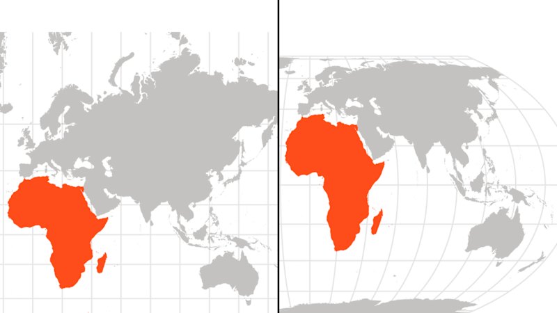
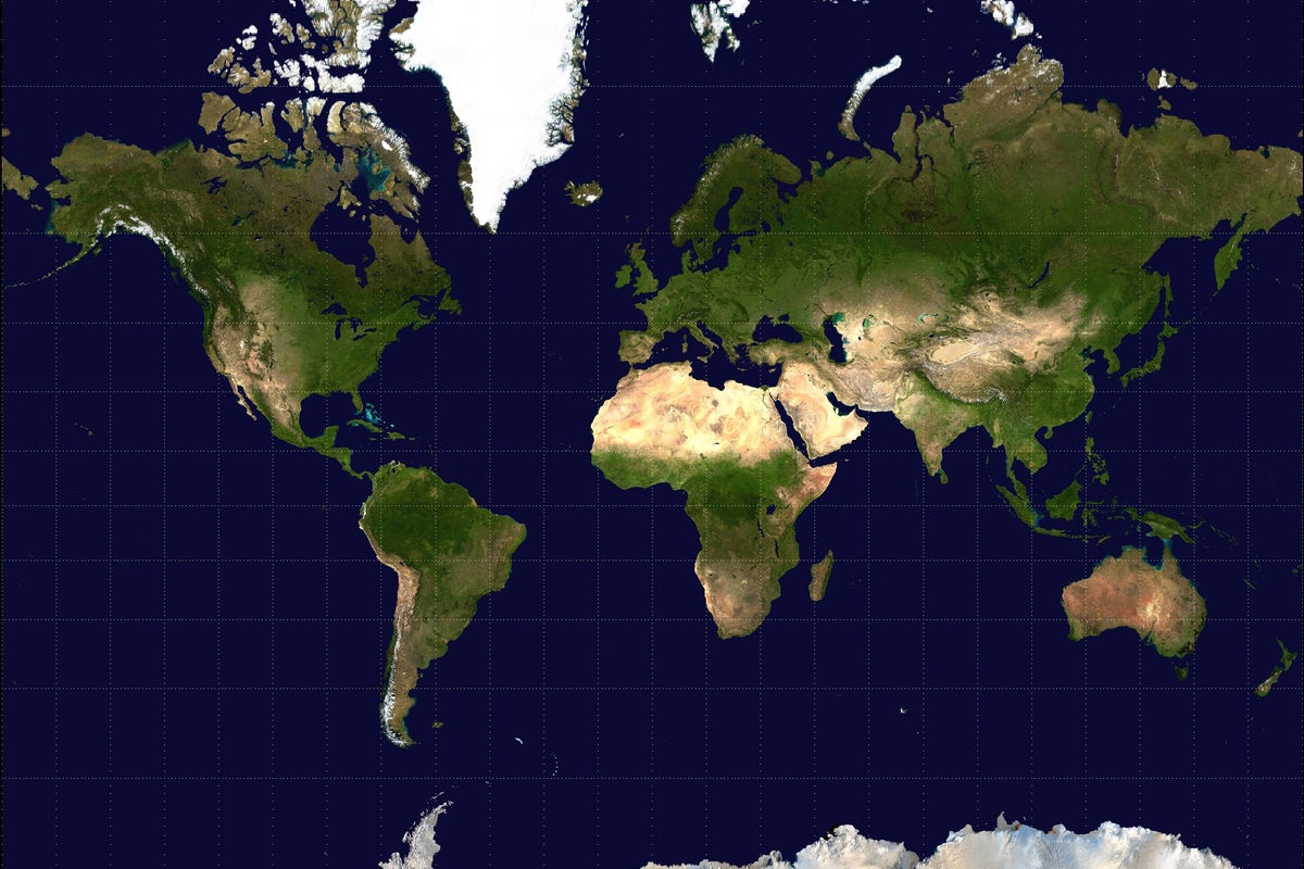
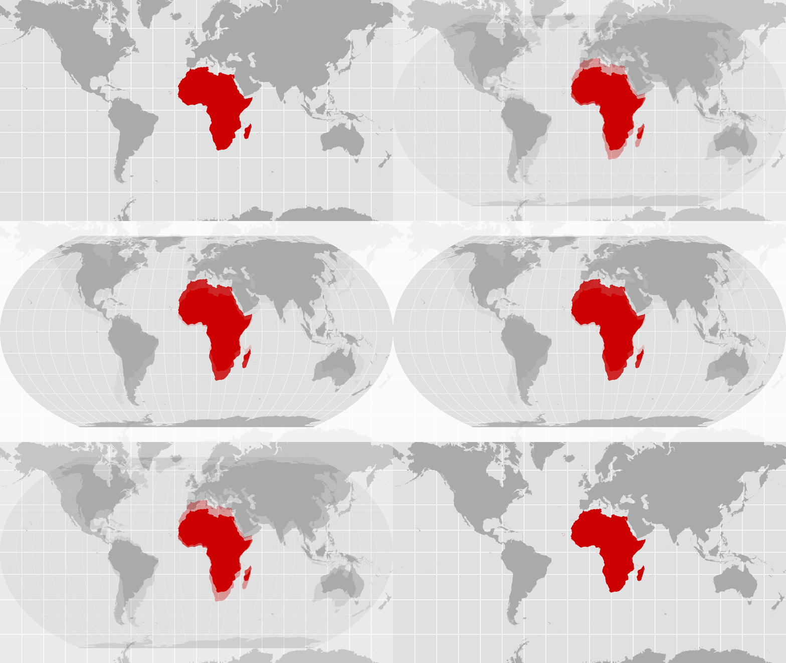
At the heart of this demand is the charge that the Mercator projection, still widely used in schools, media, and online platforms, systematically distorts the sizes of landmasses, shrinking Africa while inflating Europe, North America, and Greenland.
framing: assertive · carried by 1 article(s) · first seen 2026-09-06
By backing the call, the AU has expressed hope that a fairer projection will restore geographical accuracy and correct what it characterises as centuries of symbolic marginalisation.
2026-09-06 · The Hindu
What’s the issue with the way Africa is shown on maps? | Explained · assertive framing

Claims (6 extracted, 1 hedged)

The story so far: The African Union (AU) has endorsed the ‘Correct the Map’ campaign to replace the Mercator map projection with alternatives such as the Equal Earth map. asserted
Union → endorse → map
At the heart of this demand is the charge that the Mercator projection, still widely used in schools, media, and online platforms, systematically distorts the sizes of landmasses, shrinking Africa while inflating Europe, North America, and Greenland. asserted
projection → use → Europe
By backing the call, the AU has expressed hope that a fairer projection will restore geographical accuracy and correct what it characterises as centuries of symbolic marginalisation. asserted
it → back → marginalisation
The Mercator projection was designed in 1569 by Flemish cartographer Gerardus Mercator, who was trying to solve a navigation problem. asserted
who → design → problem
When a ship follows a fixed compass direction, the path it traces – called the rhumb line – is a curve on most flat maps. asserted
it → follow → maps
This made it awkward for sailors to translate a bearing into a usable course they could plot on a chart. uncertain
they → make → chart
Give feedback · no sign-in needed

No sign-in needed for now. Your note is sent without a name, so it cannot be answered.

History Support