Photo via Al Jazeera

Satellite images show Gaza in ruins three years into Israel’s genocidal war

Read the original at Al Jazeera ↗
Cite

Satellite images show Gaza in ruins three years into Israel’s genocidal war. (2026, September 29). Al Jazeera. https://www.aljazeera.com/news/2026/9/29/satellite-images-show-gaza-in-ruins-three-years-into-israels-genocidal-war?traffic_source=rss

Dated when The Aporia collected the article, usually within hours of publication. Check the original for its exact date and byline.

Al Jazeera · collected 2026-09-29 · by AJLabs

Quick Summary

Satellite images from Google Maps reveal extensive destruction across Gaza as a result of ongoing conflict with Israel, showing areas like Rafah and Khan Younis devastated beyond recognition. About 82 percent of structures in Gaza are damaged, with nearly two-thirds completely destroyed according to UNRWA data. The images highlight specific locations such as the Tal as-Sultan neighborhood in Rafah and the Indonesian Istiqlal Mosque in Khan Younis, both severely impacted by the conflict despite a ceasefire nearly a year ago.
Written by AI on 2026-09-29, from this article's own text only (the story summary below draws on all the coverage).

AI analysis

Story summary

Google Earth has updated its satellite imagery, revealing extensive destruction in Gaza, where Israeli military actions have severely damaged or destroyed most housing, hospitals, schools, and other buildings across the 141 square mile territory. With a population density among the world's highest, Gaza is now largely reduced to rubble. Foreign journalists and human rights groups are barred from entering, but satellite images show widespread devastation, including charred farmland and damaged historical sites. According to UNOSAT, nearly 82 percent of structures in Gaza have been affected, with roughly two-thirds destroyed, totaling around 200,000 buildings. These updates highlight the ongoing humanitarian crisis and hinder recovery efforts as Benjamin Netanyahu’s government restricts access for independent investigation.

Written for “Gaza Devastation Revealed” on 2026-11-05, grounded in this article and the 1 other(s) covering the same event.

Story

📰 Gaza Devastation Revealed
World · 2 article(s) covering the same event. See how they differ ↓

Compared with similar articles

This article reads leans strongly left and hedges 14% of its claims. Each row says how that neighbour differs.
The Independent
⚖️ Leans left further right than this Hedges 5 of 27 claims Outlet record 59/100
Al Jazeera
⚖️ Leans left further right than this Hedges 3 of 30 claims Outlet record 60/100
“The articles discuss different aspects of the situation in Gaza, one focusing on destruction and satellite imagery showing three years into Israel's conflict with Gaza, while the other focuses on medical issues faced by doctors treating patients.”
Al Jazeera
⚖️ Leans strongly left Hedges 5 of 19 claims Outlet record 60/100
“The articles describe different aspects of the ongoing conflict in Gaza; one focuses on long-term destruction over nearly three years, while the other reports a recent attack resulting in casualties.”
Washington Examiner
⚖️ Leans strongly right further right than this Hedges 1 of 16 claims Outlet record 69/100
“Article A reports on satellite images showing destruction in Gaza over three years of conflict, while Article B discusses the propaganda and narrative surrounding claims of 'genocide' regarding the same conflict but does not describe the same specific incident.”
Al Jazeera
⚖️ Leans strongly left Hedges 1 of 46 claims Outlet record 60/100
“The articles discuss different topics related to Gaza, one focusing on destruction from a war and the other on voter sentiments leading up to elections.”
Al Jazeera
Hedges 3 of 17 claims Outlet record 60/100
“The articles describe different aspects of the situation in Gaza, one focusing on satellite imagery showing destruction and the other on delayed entry of aid by WHO.”
Toronto Star
Hedges 1 of 2 claims Outlet record 64/100
“While both articles discuss the destruction and death toll in Gaza due to the ongoing conflict, they describe different aspects of the event: one focuses on the cumulative death toll since the war began, while the other describes recent satellite imagery showing the extent of physical destruction.”
The Guardian
⚖️ Leans left further right than this Hedges 1 of 15 claims Outlet record 66/100
“The articles refer to similar events but discuss satellite imagery taken at different times (nearly three years into the war vs. an update from June this year) and describe varying degrees of destruction.”
CBC News
Hedges 1 of 11 claims Outlet record 60/100
“The articles describe different aspects of the ongoing conflict; one focuses on the rising death toll, while the other reports on satellite images showing destruction in Gaza.”
How this article was measured signals, leaning charts, publisher record, byline, topics and claims

Signals How these are calculated →

Claims extracted
29
sentences that state something as happening or true
Uncertain
14%
4 of 29 hedged ("reportedly", "may", "according to")
Leaning
Leans strongly left
of the writing, not the subject · beta estimate
Publisher signals
60/100
Al Jazeera's corrections and hedging, across everything collected from it. Not a measure of accuracy.
Outlets on this story
2
World
Same framing elsewhere
1
articles that frame the event the way this one does
Analyzed 2026-09-29 · how these are computed

How this is being covered How these are calculated →

Article leaning vs. publisher reliability
Source leaning vs. consistency

Publisher

Al Jazeera · 4966 article(s) · 3 correction(s) detected
Running correction rate · 3 correction(s)

Who wrote this

No reporter is named on this article, beyond the feed's “AJLabs”.

Topics

Gaza Google Maps Israel Khan Younis Rafah

Subjects

Gaza GPE · 14× Rafah GPE · 11× Khan Younis GPE · 6× Israel GPE · 5× Jabalia GPE · 3× UNOSAT ORG · 3× Google Maps ORG · 2× Palestinians NORP · 2× Tal as-Sultan GPE · 2× UNRWA ORG · 2×

Narrative

Al-Mawasi, Rafah Al-Mawasi, once a sparsely populated coastal strip of sand and farmland stretching along the coast of the Rafah and Khan Younis governorates, was declared a “humanitarian zone” by Israel early in the war.
framing: assertive · carried by 1 article(s) · first seen 2026-09-29
🔮 Tal as-Sultan, Rafah Rafah, Gaza’s southernmost city, became a major refuge for Palestinians displaced from across Gaza, but about one million people were forced to flee the area after Israeli military operations began there in May 2024.

Claims (29 extracted, 4 hedged)

Newly updated Google Maps satellite imagery shows the scale of destruction across the besieged Gaza Strip nearly three years into Israel’s genocidal war. asserted
imagery → update → war
With neighbourhood after neighbourhood reduced to rubble and little left but the faint outlines of main roads, it is now almost impossible to tell one part of Gaza from another. asserted
it → reduce → another
Farmland has been charred, and centuries-old places of worship have been damaged or wiped from the landscape. asserted
places → char → landscape
A recent assessment by the United Nations Satellite Centre (UNOSAT) found that the number of destroyed structures across Gaza has increased by 9 percent since a “ceasefire” took effect nearly a year ago. asserted
ceasefire → find → effect
Overall, about 82 percent of structures in Gaza, roughly 200,000 buildings, have been damaged, and about two-thirds of those have been destroyed, according to the UN agency for Palestinian refugees, UNRWA. uncertain
thirds → damage → refugees
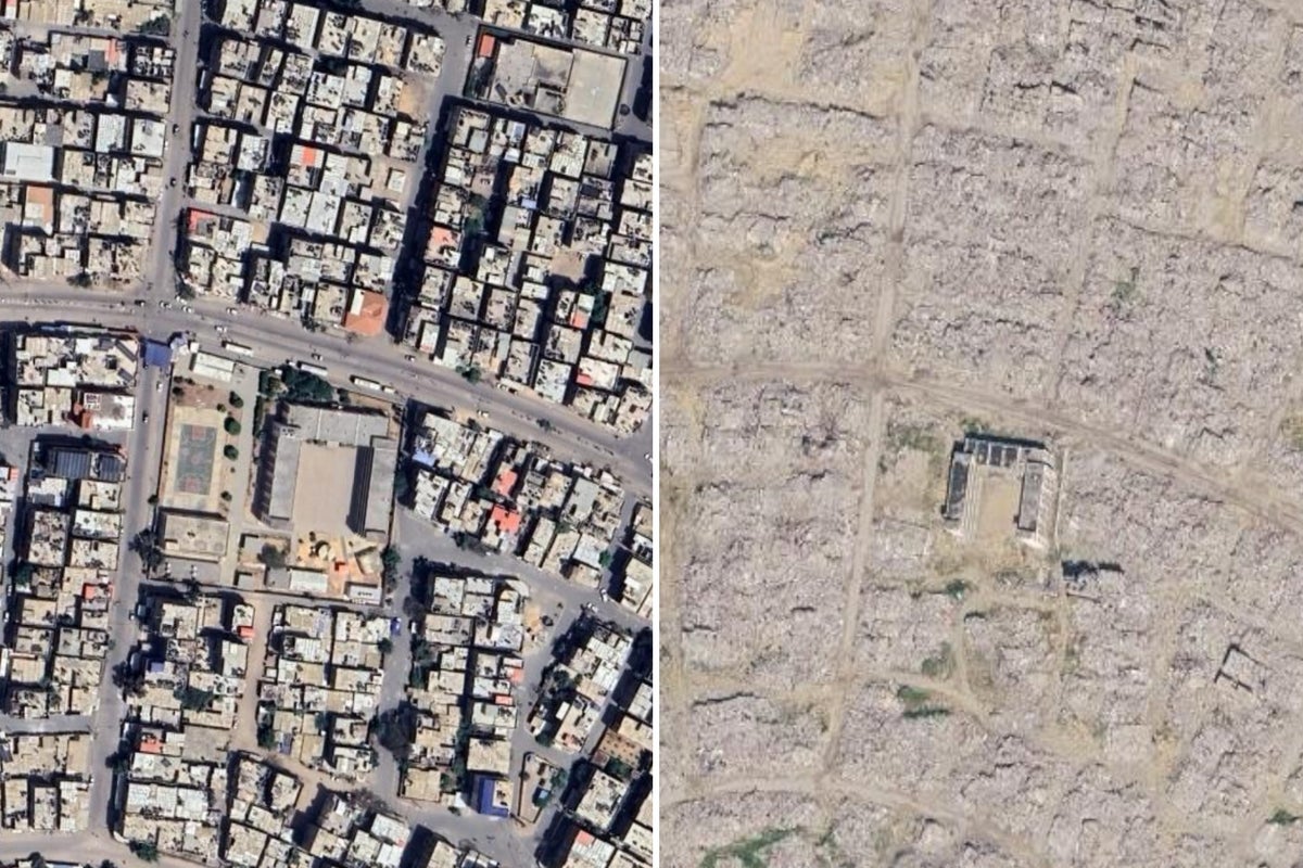
Using satellite images recently released on Google Maps, Al Jazeera compared Gaza before the war with today, from Rafah in the south to North Gaza. asserted
Jazeera → use → Gaza
The images of Rafah were captured this year while those of northern Gaza date from 2025 and 2024. asserted
those → capture → 2025
Drag the slider to the left to see what remains of some of Gaza’s neighbourhoods. asserted
what → drag → neighbourhoods
Tal as-Sultan, Rafah Rafah, Gaza’s southernmost city, became a major refuge for Palestinians displaced from across Gaza, but about one million people were forced to flee the area after Israeli military operations began there in May 2024. uncertain
operations → become → May
Most had already been displaced multiple times and were forced to move towards Khan Younis, a city just north of Rafah, and Deir el-Balah in central Gaza as UNRWA shelters in Rafah were emptied. asserted
shelters → displace → Rafah
In western Rafah, the once densely populated Tal as-Sultan neighbourhood has been almost entirely wiped out. asserted
neighbourhood → wipe → Rafah
Satellite images showed little more than sand where homes once stood. asserted
homes → show → sand
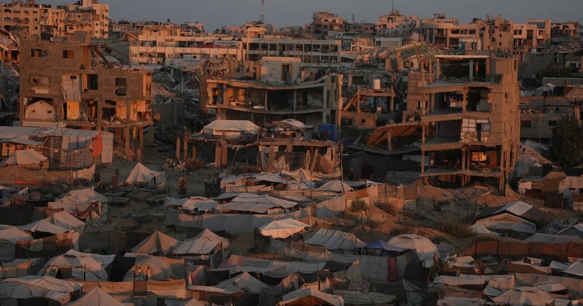
Al-Mawasi, Rafah Al-Mawasi, once a sparsely populated coastal strip of sand and farmland stretching along the coast of the Rafah and Khan Younis governorates, was declared a “humanitarian zone” by Israel early in the war. asserted
Mawasi → stretch → war
It told displaced Palestinians to seek safety there. asserted
It → tell → safety
In May 2024 as Israel prepared to invade the city of Rafah, then-US President Joe Biden warned: “If they go into Rafah, … I’m not supplying the weapons.” uncertain
I → prepare → weapons
Israel went ahead with the operation, pushing hundreds of thousands more people into al-Mawasi, which it has since bombed repeatedly. asserted
it → go → which
The latest satellite images show the once largely empty area now covered in tents and packed with families who have nowhere else to go. asserted
who → show → nowhere
Indonesian Istiqlal Mosque, Khan Younis Khan Younis recorded the highest number of damaged structures of any governorate in UNOSAT’s October 2025 assessment with 51,885 structures. asserted
Mosque → record → structures
The governorate was also one of Gaza’s main agricultural hubs, and Khan Younis has recorded the largest total area of damaged cropland in the Gaza Strip. asserted
Younis → record → Strip
The Indonesian Istiqlal Mosque in the Ma’an area of Khan Younis was destroyed during the war after being reopened less than two years earlier. asserted
Mosque → destroy → war
Port of Gaza, Gaza City Gaza governorate recorded the second-highest number of damaged structures in UNOSAT’s October 2025 assessment at 51,530 with 41,663 in Gaza City alone. asserted
Port → record → City
Among the worst-hit sites has been Gaza City’s port, the heart of a fishing industry that once supported about 110,000 people. asserted
that → hit → people
The UN Food and Agriculture Organization said the port has been severely damaged and most of its fishing boats destroyed. asserted
most → say → boats
Jabalia refugee camp, North Gaza The North Gaza governorate had the highest proportion of damaged cropland in the Strip with 94 percent damaged by July 2025, according to the UN’s Office of Humanitarian Affairs. uncertain
percent → have → Affairs
During the war, Beit Lahiya, Jabalia and other communities in the north were subjected to repeated Israeli military operations, forced displacements and severe restrictions to humanitarian aid. asserted
Lahiya → subject → aid
Jabalia refugee camp, the largest of Gaza’s eight camps, has been destroyed with satellite images showing entire blocks reduced to rubble. asserted
blocks → destroy → rubble
Since Israel’s war on Gaza began on October 7, 2023, more than 74,000 Palestinians have been killed and more than 175,000 have been injured. asserted
175,000 → begin → October
The true toll is likely higher because many people are still missing beneath the rubble. asserted
people → miss → rubble
Since the October “ceasefire” last year, more than 1,400 people have been killed and almost 5,000 injured. asserted
5,000 → kill → ceasefire

💬Give feedback · no sign-in needed

No sign-in needed for now. Your note is sent without a name, so it cannot be answered.

🕘History 🎫Support